| Accession Number | AWM2018.6.74 |
|---|---|
| Collection number | 3DRL/2316, 3DRL/2316.034 |
| Collection type | Digitised Collection |
| Record type | Item |
| Item count | 1 |
| Object type | Map |
| Physical description | 2 Image/s captured |
| Conflict |
First World War, 1914-1918 |
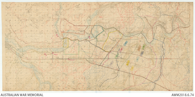
Composite trench map of Western Front area between Amiens and Chuignes
Description
[3DRL/2316 Series 10 Map 170] Composite trench map of Western Front area between Amiens and Chuignes. Created from approx 4, 1:20 000 scale map sheets, cut and pasted together. Original sheet titles and key have been removed. Trenches printed in red and blue. Hand annotations show Australian Corps boundaries, objective lines, forming up and objective areas for infantry brigades attacking on 8 August 1918. Corps boundary lines are coloured brown until beyond the jumping off line when they become black. Objective lines are green, red and blue indicating first, second and third objective lines respectively. Brigades are numbered and colour coded, eg 11 Brigade is dark blue, 15 Brigade light yellow. Divisional HQ's marked in red. Bottom right corner has 13 in blue pencil in a blue circle and in pencil [3DRL/2316 50/170]. Rear top right corner has 170 stamped in blue ink, next to blue pencil 18. This map was probably used in briefings of officers during the planning for the 8 August operations.