| Accession Number | RC11577.1681 |
|---|---|
| Map call number | G8033.S3 s25 |
| Collection type | Published Collection |
| Record type | Item |
| Item count | 1 |
| Object type | Map |
| Maker |
2/1 Australian Army Topographical Survey Company |
| Date made | 1945 |
| Conflict |
Second World War, 1939-1945 |
| Copying Provisions | Digital format and content protected by copyright. Non-commercial use permitted. |
Enemy information up to 24 Apr 45 : [overprinted on] Labuan north (special): Borneo 1:25,000, sheet 3147-II Special
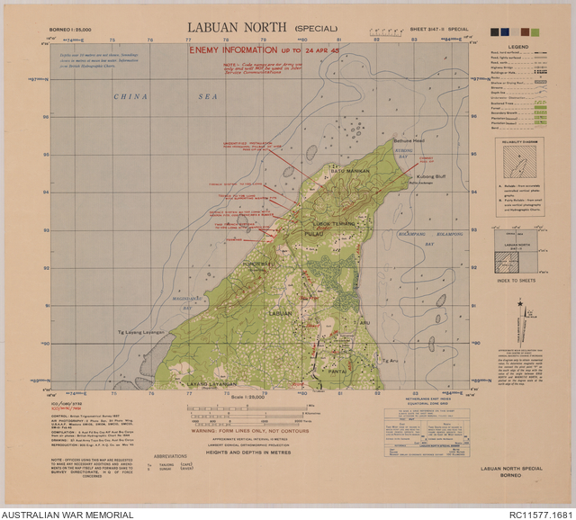
Description
A single sheet from the topographical map series (T831), covering the northern part of Labuan Island and surrounding area, and overprinted with enemy defence information as of 24 April 1945. Overprint shows Japanese trench systems with supporting weapon pits and bunkers, possible observation posts, and Australian Army code names for various geographic features. Base map shows the South China Sea, bays on northern Labuan, sea depths, rocks and reefs, Raffles Anchorage at Kubong Bluff, populated places and isolated buildings, roads and tracks, cultivated areas and other vegetation and terrain features. Relief shown by form lines, bathymetric soundings and isolines. "ICO/MISC/7491". Includes legend, index to sheets, and reliability diagram. Compilation, 5 Aust Fd Svy Coy AIF, Aust Svy Corps ; drawing, 2/1 Aust Army Topo Svy Coy, Aust Svy Corps / [GSI 1 Aust Corps].