| Place | Asia: Netherlands East Indies, Moluccas Islands |
|---|---|
| Accession Number | AWM2022.10.62 |
| Collection number | G8070.S73 svar |
| Collection type | Digitised Collection |
| Record type | Item |
| Item count | 1 |
| Object type | Map |
| Physical description | 2 Image/s captured |
| Maker |
US Army Map Service |
| Place made | United States of America: Washington DC |
| Date made | [1956?] |
| Conflict |
Indonesian Confrontation, 1962-1966 |
| Source credit to | This item has been digitised with funding provided by Commonwealth Government. |
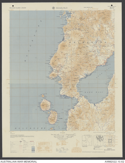
Djailolo, Molukken Islands
Description
A topographical map adhered to linen titled 'Djailolo' covering the area around the town of Tjailolo (Jailolo), on the central west coast of the island of Halmahera, Indonesia. Scale 1:250,000, edition 1, sheet NA 52 N, series L561, US Army Map Service. Shows the Molucca Sea coastline, Kau Bay, Ternate, Tidore and other smaller islands, main populated places, roads and tracks, rivers, mangrove and wetland areas, terrain features. Relief shown by contours and spot heights. Includes legend, glossary, index to adjoining sheets, index to boundaries, and coverage diagram.
Related information
Related Objects
- Map Overlay, Djailolo, Indonesia; Terrain Regions
- Map Overlay, Djailolo, Indonesia; Vegetation and Land Use
- Map Overlay, Djailolo, Indonesia; Airfields and Landing Sites
- Map Overlay, Djailolo, Indonesia; Land Transportation, Communications and Settlement
- Map Overlay, Djailolo, Indonesia; Beaches, Ports and Waterways
- Map Overlay, Djailolo, Indonesia; Climate