Australian War Memorial Logo
Search
  • Online Shop Use this login for Shop items, and image, film, sound reproductions
    Cart  |  Log In
  • Collection Open Information Close Information
    • Official Histories & Unit Diaries
    • Understanding the Collection
    • Research at the Memorial
    • Donating to the Collection
    • National Collection Loans
    • Projects
  • People
  • Visit
  • Commemorate Open Information Close Information
    • Last Post Ceremony
    • Honour Rolls
    • Anzac Day
    • Remembrance Day
    • Customs & Ceremony
    • Speeches
  • Learn Open Information Close Information
    • Schools & Teachers
    • Memorial Articles
    • Encyclopedia
    • Understanding Military Structure
    • Podcasts
    • Glossary
    • Wartime Magazine
  • Get Involved Open Information Close Information
    • Donations & Bequests
    • Corporate Partnership
    • Employment Opportunities
    • Volunteer at the Memorial
    • Friends of the Memorial
    • eMemorial Newsletter
    • Grants, Scholarships & Residencies
    • Research Papers
  • Shop Open Information Close Information
    • Help and Information
    • Lone Pine Seedlings
    • Images, film and sound

Breadcrumb

  1. Home
  2. Memorial Articles
  3. blog
  4. Relief maps of the Western Front

Main navigation

  • Our People
  • Our Work
  • Our Organisation
  • Media Centre
  • Memorial Articles
    • Australians and Peacekeeping
    • Australians at war
    • Gulf War 1990-1991
    • Journal of the Australian War Memorial
    • Korean War 1950 - 1953
    • NAIDOC Week
    • RAAF Centenary
    • Victory in the Pacific Day
  • Speeches

Relief maps of the Western Front

Dianne Rutherford

13 July 2007
3 mins read
Image of the relief map of Polygon Wood, contained in a wooden box with a modern perspex cover. The details of the map have been hand drawn on the map.
Relief map of Polygon Wood scale 1:10,000


Background

A series of three-dimensional relief maps was made in London in 1919 by a subsection of the Australian War Records Section (AWRS, the parent organisation of the Australian War Memorial).

Modelling Subsection 5AW, who created the maps, was established sometime around December 1918 and was managed by Lieutenant Cyril Isaac. In civilian life Isaac worked for the Education Department in Victoria. During the war he served with the 58th Battalion in Europe before joining the AWRS. The role of 5AW was to create three dimensional maps of the battlefields of France and Belgium and to later train staff in Egypt how to make similar maps of Gallipoli and Palestine.

Image of 17 members of the AWRS Modelling Subsection constructing relief maps.
London, May 1919 the Modelling Subsection 5AW of the AWRS


Very few records from 5AW exist today and the reasons behind the maps’ creation are unclear. Records indicate they may have been created to help people who could not read contours on maps understand the terrain fought on by Australians, or as a precursor to the construction of larger battlefield plan models that were displayed in the Memorial’s galleries. The latter seems unlikely as Subsection 4AW was making the plan models at the same time that relief maps were made.

A third possibility is provided in a story that has circulated around staff at the Memorial, that the maps were created to aid C.E.W. Bean in writing the official histories of Australians in the First World War. It is possible that Bean used them whilst writing, but nothing has been found in the Memorial’s files or Bean’s papers to confirm this.

Image of the relief map of Peronne, contained in a wooden box with a modern Perspex cover. The details of the map have been hand drawn on the map.
Relief map of Peronne, scale 1:10,000


Technique

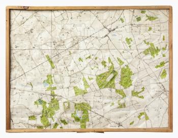
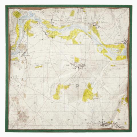
The maps were created by modelers and draftsmen. The modeler gradually built up the contours by making levels, or steps, possibly from plywood. Once all the levels were complete a coating of papier mache was placed over them. The papier mache was made with fine paper pulp and a heated clear glue called “small cake glue”. The modelers mixed the hot glue with paper pulp with most of the water squeezed out of it. They relied mostly on their sense of touch, working the mixture until it felt smooth, like plastic. The papier mache was smoothed and rounded to make the contours.

Once the map was dried, draftsmen transferred the details from the relevant trench map by hand. All details, including map grid squares were included on the items as they were maps in the truest sense of the word, not just models of the landscape.

Image of the relief map of Hamel, contained in a wooden box with a modern Perspex cover. The details of the map have been hand drawn on the map.
Relief map of Hamel scale 1:10,000


Coverage

The Memorial holds maps of France and Belgium. While the AWRS planned on making relief maps of Palestine and Gallipoli, these never eventuated. There are 22 relief maps in the Memorial’s collection covering areas in France and Belgium, including Pozieres, Peronne, Villers-Bretonneux, Bullecourt, and Fromelles.

Sources:

Rutherford, Dianne, 'Teaching the terrain: First World War battlefields at the Australian War Memorial.' Published in The Globe Issue 55, 2004.

AWM16 4372/1/14 Series of relief maps of France, Gallipoli and Egypt made by Australian War records Section

AWM16 4372/21/16 Equipment for modelling

AWM93 13/1/10 Recipe for making paper-mache (plastic pulp) for models by Lieut C.E. Isaac

Author

Dianne Rutherford

Last updated: 30 March 2021

  • Back to Articles
Explore the Collection

Explore the Collection

Our collection contains a wealth of material to help you research and find your connection with the wartime experiences of the brave men and women who served in Australia’s military forces.

Find out more
The Donations and bequests

Donations & Bequests

Your generous donation will be used to ensure the memory of our Defence Forces and what they have done for us, and what they continue to do for our freedom remains – today and into the future.

Find out more
The placesofpride

Places of Pride

Places of Pride, the National Register of War Memorials, is a new initiative designed to record the locations and photographs of every publicly accessible memorial across Australia.

Find out more
Visit the Australian War Memorial

Visit the Australian War Memorial

The Australian War Memorial is open for visitors as we work to expand our galleries. All visitors require a free timed ticket to enter the Memorial Galleries and attend the Last Post Ceremony.

Find out more
Canberra Highlands in Grayscale

ACKNOWLEDGEMENT OF
TRADITIONAL CUSTODIANS

The Australian War Memorial acknowledges the traditional custodians of country throughout Australia. We recognise their continuing connection to land, sea and waters. We pay our respects to elders past and present.
Location map of The Australian War Memorial
The Australian War Memorial building

The Australian War Memorial

Treloar Crescent
Campbell ACT 2612
Australia
View on Google Maps (opens in new window)
Google Map data ©2023 Google
Australian War Memorial Logo
  • Go to AWM Facebook
  • Go to AWM Twitter
  • Go to AWM Trip Advisor
  • Go to AWM Instagram
  • Go to AWM Youtube

Footer

  • Memorial Articles
  • About
  • Contact
  • Media
  • Wartime Magazine
  • Donate Today

The Australian War Memorial

Treloar Crescent

Campbell ACT 2612

Australia


Opening Hours

10 am to 5 pm daily (except Christmas Day)


In preparation for the daily Last Post Ceremony,

galleries are progressively closed from 4 pm.


Public entrance via Fairbairn Avenue, Campbell ACT 2612

Book your ticket to visit: awm.gov.au/visit


Please enter a valid email address

Legal

  • Copyright
  • Disclaimer
  • Privacy Policy
  • Accessibility
  • Freedom of information

Copyright 2023 Australian War Memorial, Canberra. All rights reserved