Australian War Memorial Logo
Search

Donate Today

  • Collection Open Information Close Information
    • Official Histories & Unit Diaries
    • Understanding the Collection
    • Research at the Memorial
    • Donating to the Collection
    • National Collection Loans
    • Projects
  • People
  • Visit
  • Commemorate Open Information Close Information
    • Last Post Ceremony
    • Honour Rolls
    • Anzac Day
    • Remembrance Day
    • Customs & Ceremony
    • Speeches
  • Learn Open Information Close Information
    • Schools & Teachers
    • Memorial Articles
    • Encyclopedia
    • Understanding Military Structure
    • Podcasts
    • Glossary
    • Magazine
  • Get Involved Open Information Close Information
    • Donations & Bequests
    • Corporate Partnership
    • Employment Opportunities
    • Volunteer at the Memorial
    • Friends of the Memorial
    • eMemorial Newsletter
    • Grants, Scholarships & Residencies
    • Research Papers
  • Shop Open Information Close Information
    • Memorial Shop
    • Images, film and sound
    • Lone Pine Seedlings

Breadcrumb

  1. Home
  2. Research at the Memorial
  3. Research
  4. Reading map references: First World War, Western F...

Main navigation

  • Aboriginal and Torres Strait Islander military service
  • Afghanistan, 2001-2021
  • British Commonwealth Occupation Force (BCOF)
  • East Timor, 1999-2003
  • First World War, 1914-1918
  • Gulf War, 1990–1991
  • Indonesian Confrontation, 1963–1966
  • Iraq, 2003-2009
  • Korean War, 1950–1953
  • Malayan Emergency
  • Names on an honour board
  • New Zealand, 1860–66
  • Peacekeeping
  • Researching Aboriginal and Torres Strait Islander military service
  • Second World War, 1939-1945
  • South African War (Boer War), 1899–1902
  • Sudan, 1885
  • Vietnam War, 1962-1975
  • Local information sources about Australians at war

Reading map references: First World War, Western Front

Trench maps from the First World War can aid in identifying the areas in which units and individuals served and their movements.

Identifying map references

Map references identify a specific location and are often seen in unit war diaries and service records. These references consist of five parts. For example the map reference for Mouquet Farm is 57d.R.33.b.3.9.

Sheet number

The first part of the map reference is the sheet number, “57d” in the Mouquet Farm example above. The number identifies the 1:40,000 small scale map sheet on which the reference falls.

Letter grid square

Each 1:40,000 map sheet was divided into 24 squares of 6,000 yards designated by a capital letter, the ‘R’ in the Mouquet Farm reference above.

Numbered map square

Each 6,000-yard square was then further subdivided into 36 squares of 1,000 yards and assigned a number, the “33” in the Mouquet Farm reference above.

Quadrant

The numbered squares were then divided into 500-yard quadrants assigned a lower case a, b, c, or d as shown in the diagram below. This is the “b” in the Mouquet Farm reference above. 

Grid coordinates

Grid coordinates were used to assign a more specific reference down to tenths of the square, or 50 yards. This is the “3.9” in the Mouquet farm reference above. These coordinates are read from the south-west corner of the quadrant. Point “p” in the diagram below is located three-tenths east and four-tenths north; therefore it is located at “5.b.3.4”.

Map grid coordinates example

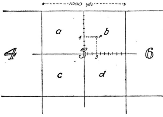
Diagram 1 from Great Britain War Office General Staff, Maps and Artillery Boards (HMSO, 1917): 8

These coordinates are occasionally shown as a four-figure reference, e.g. “25.85”, specifying to five-yard accuracy.

Notes on scale

1:40,000 scale maps were a complete sheet and depicted an area approximately 32 km wide by 22 km high. They were primarily used for planning operations for formations from Brigade level upwards. These maps may indicate the rough front-line, but trench systems are generally not shown. 1:40,000 sheets are referred to just by the sheet number.

1:20,000 scale maps cover a quarter of a 1:40,000 sheet and depict an area approximately 16 km east to west and 11 km north to south. These sheets were used primarily by the artillery and for planning purposes. 1:20,000 map sheets are referenced by the map sheet and quadrant e.g. 36 N.E., 57c N.W. etc.

1:10,000 scale maps cover a quarter of a 1:20,000 sheet and depict an area of approximately 8 km east to west, and 5.5 km north to south. 1:10,000 sheets are numbered by which quarter they cover of the 1:20,000 sheet: 1 and 2 are the upper left and right, and 3 and 4 are the lower left and right respectively, e.g. 57d N.W.1, 62c S.E. 2.

For help locating First World War trench maps, see our information sheet Finding First World War Western Front maps.

Download information sheet

  • Portable Document FormatReading map references: First World War, Western Front [192.7 kB PDF]

Last updated: 16 December 2020

1 The Donations and bequests

Donations & Bequests

Your generous donation will be used to ensure the memory of our Defence Forces and what they have done for us, and what they continue to do for our freedom remains – today and into the future.

Find out more
2 Visit Transcribe.awm.gov.au

Transcribe

Help preserve Australia's history by transcribing records from the National Collection. Enhance accessibility and discoverability for all Australians.

Find out more
The placesofpride

Places of Pride

Places of Pride, the National Register of War Memorials, is a new initiative designed to record the locations and photographs of every publicly accessible memorial across Australia.

Find out more
Visit the Australian War Memorial

Visit the Australian War Memorial

The Australian War Memorial is open for visitors as we work to expand our galleries. Entry is free and tickets are not required.

Find out more
Canberra Highlands in Grayscale

ACKNOWLEDGEMENT OF
TRADITIONAL CUSTODIANS

The Australian War Memorial acknowledges the traditional custodians of country throughout Australia. We recognise their continuing connection to land, sea and waters. We pay our respects to elders past and present.
Location map of The Australian War Memorial
The Australian War Memorial building

The Australian War Memorial

Fairbairn Avenue
Campbell ACT 2612
Australia
View on Google Maps (opens in new window)
Google Map data ©2025 Google
Australian War Memorial Logo
  • Go to AWM Facebook
  • Go to AWM Trip Advisor
  • Go to AWM Instagram
  • Go to AWM Youtube

Footer

  • About
  • Contact
  • Venue Hire
  • Media
  • WM Magazine
  • Donate Today

The Australian War Memorial

Fairbairn Avenue

Campbell ACT 2612

Australia


Opening Hours

10 am to 4 pm daily (except Christmas Day)


In preparation for the daily Last Post Ceremony,

galleries are progressively closed from 3:40 pm.


Public entrance via Fairbairn Avenue, Campbell ACT 2612

Sign up to our newsletter

Subscribe

Legal

  • Copyright
  • Disclaimer
  • Privacy Policy
  • Accessibility
  • Freedom of information

Copyright 2025 Australian War Memorial, Canberra. All rights reserved