Finding First World War maps: Western Front
Trench maps from the First World War can aid in identifying the areas in which units and individuals served and their movements. More detailed information on reading First World War map references can be found on the information sheet Reading map references: First World War, Western Front.
Map sheet index
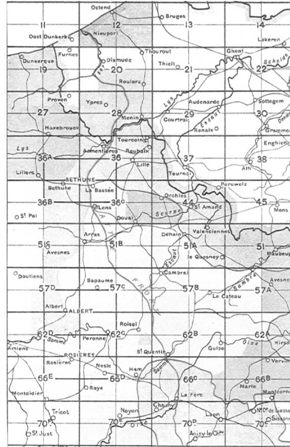
First World War maps produced by British and allied forces used a grid system to identify map sheets. This grid is shown in the diagram below.

Diagram 6 from Great Britain War Office General Staff, Maps and Artillery Boards (London: HMSO, 1917)
If you do not have a map reference, or the reference does not include a sheet number, the index can identify the map sheet covering a particular area.
Map sheets for major operations
The table below shows the map sheet numbers for major actions involving the Australian Imperial Force.
| Battle | Map sheet | Battle | Map sheet | Battle | Map sheet |
|---|---|---|---|---|---|
| Amiens | 62d | Hamel | 62d | Passchendaele | 20, 28 |
| Bapaume | 57c | Hazebrouck | 27, 36a | Poelcappelle | 28 |
| Broodseinde | 28 | Lagnicourt | 57c | Polygon Wood | 28 |
| Bullecourt | 51b, 57c | Messines | 28 | Pozieres | 57d |
| Dernancourt | 62d | Mont St Quentin | 62c | St Quentin Canal | 57b, 57c, 62b, 62c |
| Fromelles | 36 | Mouquet Farm | 57d | Villers Bretonneux | 62d |
Where to find maps
The Memorial’s collection of maps can be searched through the books database:
• Scale 1:40,000 maps can be found by searching the sheet name, e.g. “Sheet 57d”
• Scale 1:20,000 maps can be found by searching the sheet name and quadrant e.g. “Sheet 57d S.E.”
• Scale 1:10,000 maps can be found by searching the sheet name with the quarter added e.g. “Sheet 28 S.E. 2”. Please note that 1:10,000 scale maps were not created for all map sheets.
Some First World War maps are held in other libraries. These collections can be searched through Trove.
The Australian Army History Unit has digitised a portion of its trench maps of the Western Front and these are accessible on their website.
Trench maps from France and Belgium are available online on the McMaster University website.
Maps from 1917 and 1918 are available through the North Carolina Digital Collections online.
Transferring a location to a modern map
The National Library of Scotland have georeferenced a collection of over 130 British First World War trench maps and overlaid them on modern maps.
Useful references
Peter Chasseaud, Artillery’s astrologers: a history of British survey and mapping on the Western Front 1914-1918 (Lewes: Mapbooks, 1999)
Peter Chasseaud, Mapping the First World War: the Great War through maps from 1914-1918 (London: Collins in association with the Imperial War Museum, 2013)
Great Britain War Office, General Staff, Maps and artillery boards (London: HMSO, 1918)
E.M. Jack, Report on survey on the Western Front, 1914-1918 (London: HMSO, 1920)